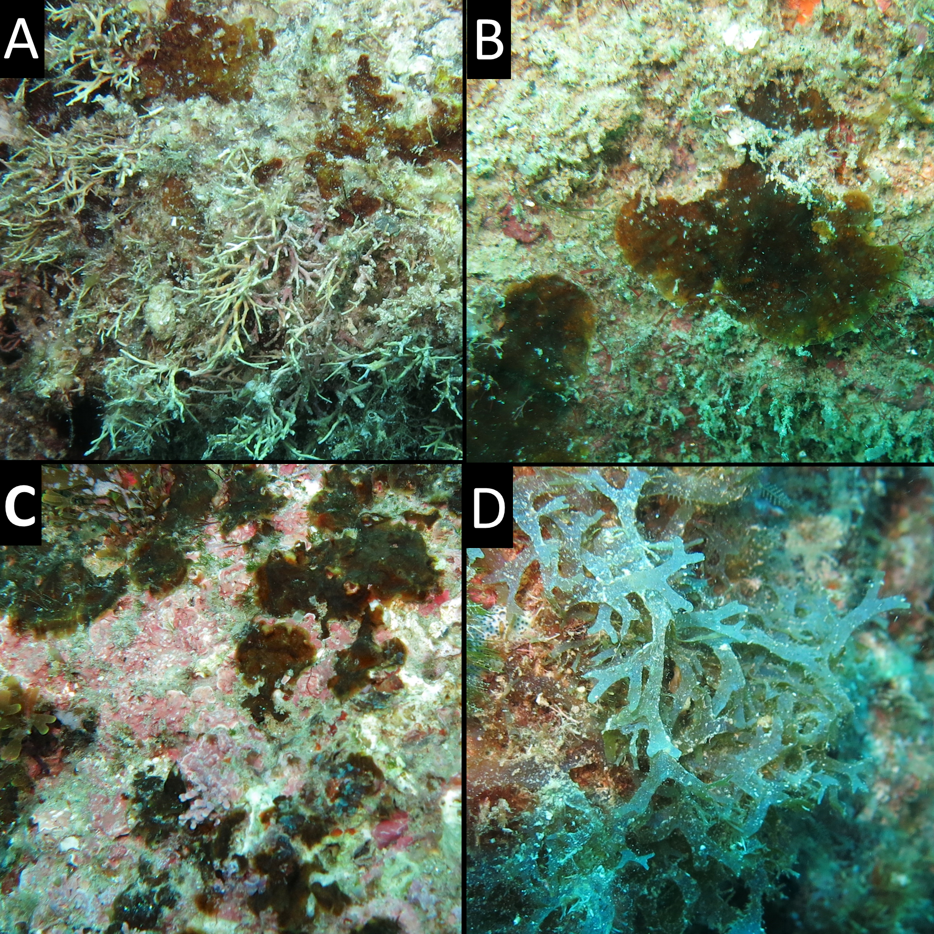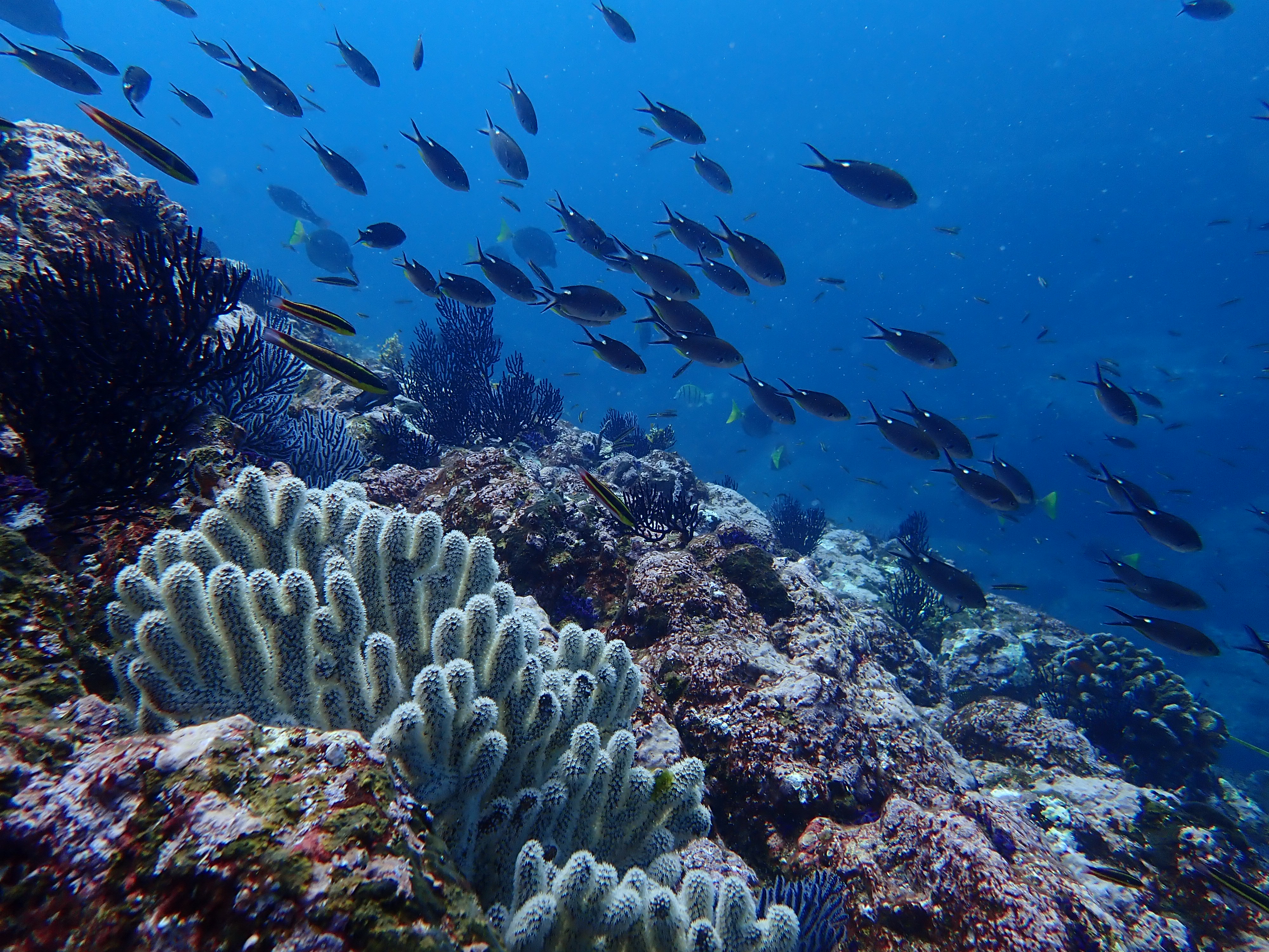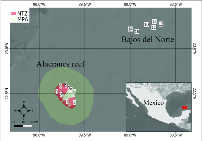
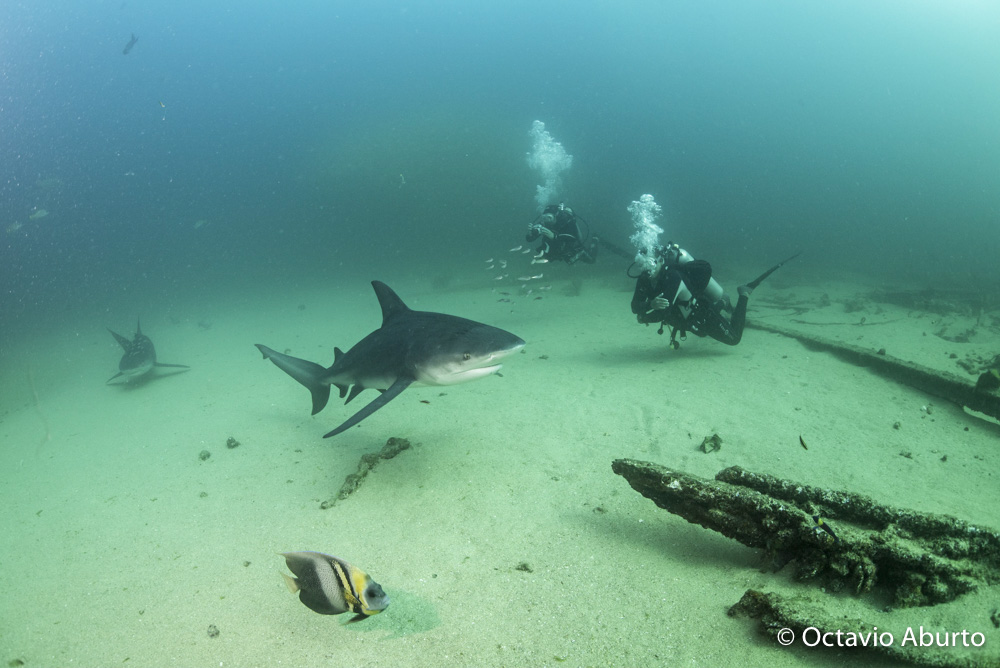
Isolated reefs suffered from overfishing to a lesser extent than coastal reefs systems. Nevertheless, the exploitation of coastal areas forced fishers to move offshore to compensate for their decreasing catches, helped by an overall increase in their technological capabilities. Thus, these once pristine isolated areas are under increasing threat and should be considered a protection priority. Here, we compared the fish and epibenthic community of two isolated coral reefs in the southern Gulf of Mexico: one is the Alacranes reefs a Marine Protected Area (MPA) with two No-Take Zones (NTZs) and the other is Bajos del Norte an Open Area (OA). Alacranes reef is ~135 km off the northern coast of the Yucatan Peninsula while Bajos del Norte ~160 km. Our results show that despite being isolated, the OA reefs never reach the same biomass levels of MPA or NTZ reefs which in some cases exceeded 1 ton/ha. Furthermore, 70% of the reefs within NTZ and MPA had a large predatory fish (e.g., sharks, jackfish, groupers) biomass relative contribution larger than 25%, while only two reefs in the OA had a relative piscivore contribution of more than 25%. Large predatory fish have a larger contribution to overall biomass within NTZs than MPAs reefs, even at low biomass values, suggesting that NTZ is more effective in protecting large predators. NTZ and MPA reefs also showed from 5 to 10% higher coral cover than OA which had a higher erect algae cover (22.9%). Indicating that the disruption of the trophic pyramid caused by the fishing pressure in OA reefs is reflecting on the trophic cascades controlling the benthic communities balance. These isolated areas represent the last pillars of natural diversity and are under such an increasing anthropogenic pressure that just being isolated is not enough anymore to guarantee a safe zone from detrimental activities like overfishing. Immediate establishment of protective NTZ is needed to maintain the role they play as a natural wilderness capital.
Fabio Favoretto, Ismael Mascareñas-Osorio, Lorena Leon-Deniz, Carlos González-Salas, Horacio Pérez España, Mariana Rivera-Higueras, Miguel-Ángel Ruiz-Zárate, Alejandro Vega-Zepeda, Harold Villegas-Hernández, Octavio Aburto-Oropeza
In Frontiers in Marine Science,
2020
Global coastal environments are highly vulnerable to degradation due to anthropogenic pressures as they host close to half of the world’s population in addition to having rich marine and terrestrial biodiversity. Worldwide degradation of coastal environments causes marine biodiversity to become an increasingly scarce resource. Consequently, locations with rich marine biodiversity have become attractive destinations for non-extractive activities such as diving tourism. For instance, since the invention of SCUBA in 1942, diving tourism has evolved from a niche activity to a thriving industry that lures practitioners with the promise of experiencing pristine wildlife encounters. Despite the number and popularity of diving destinations in Mexico, no study has previously estimated the economic importance of this industry for the Mexican case. This study calculates for the first time the gross and net revenues generated by the Mexican diving industry. We first created the most comprehensive and up-to-date list of diving sites in Mexico. Secondly, via a face-to-face survey, we gathered data on revenues and operation costs from diving operators. The resulting dataset includes 860 diving sites that together generate gross revenues ranging from (2019) USD 455 million and USD 725 million annually which are comparable to those generated by the artisanal and industrial Mexican fisheries together. Mexico simultaneously has high untapped ecotourism potential and the need for a sustainable strategy that delivers growth in both the economy and environmental conservation. Therefore, Mexico is in a position to become a beacon for community-led management through ecotourism, stimulating a sustainable use of marine resources.
Ramiro Arcos-Aguilar, Fabio Favoretto, Joy Kumagai, Victoria Jiménez-Esquivel, Adan Martinez-Cruz, Octavio Aburto-Oropeza
In MP,
2020
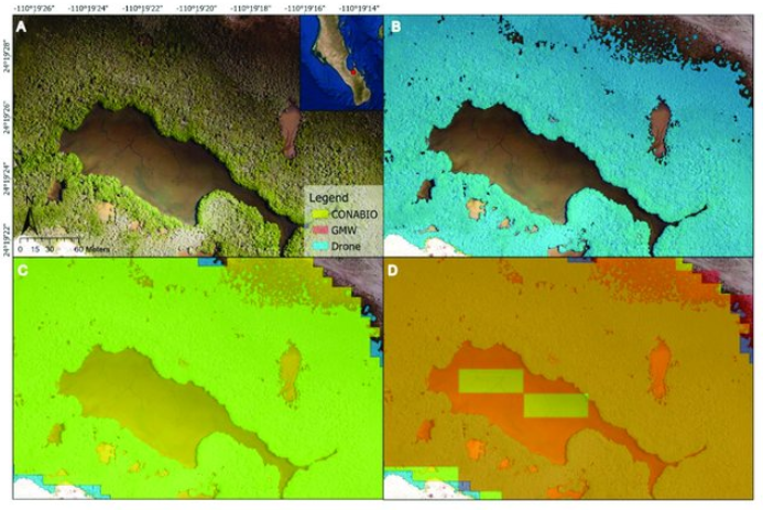
This study investigated how different remote sensing techniques can be combined to accurately monitor mangroves. In this paper, we present a framework to use drone imagery to calculate correction factors which can improve the accuracy of satellite-based mangrove extent. We focus on semi-arid dwarf mangroves of Baja California Sur, Mexico, where the mangroves tend to be stunted in height and found in small patches, as well as larger forests. Using a DJI Phantom 4 Pro, we imaged mangroves and labeled the extent by manual classification in QGIS. Using ArcGIS, we compared satellite-based mangrove extent maps from Global Mangrove Watch (GMW) in 2016 and Mexico’s national government agency (National Commission for the Knowledge and Use of Biodiversity, CONABIO) in 2015, with extent maps generated from in situ drone studies in 2018 and 2019. We found that satellite-based extent maps generally overestimated mangrove coverage compared to that of drone-based maps. To correct this overestimation, we developed a method to derive correction factors for GMW mangrove extent. These correction factors correspond to specific pixel patterns generated from a convolution analysis and mangrove coverage defined from drone imagery. We validated our model by using repeated k-fold cross-validation, producing an accuracy of 98.3% ± 2.1%. Overall, drones and satellites are complementary tools, and the rise of machine learning can help stakeholders further leverage the strengths of the two tools, to better monitor mangroves for local, national, and international management.
Astrid J. Hsu, Joy Jumagai, Fabio Favoretto, John Dorian, Benigno Guerrero Martinez, Octavio Aburto-Oropeza
In RS,
2020
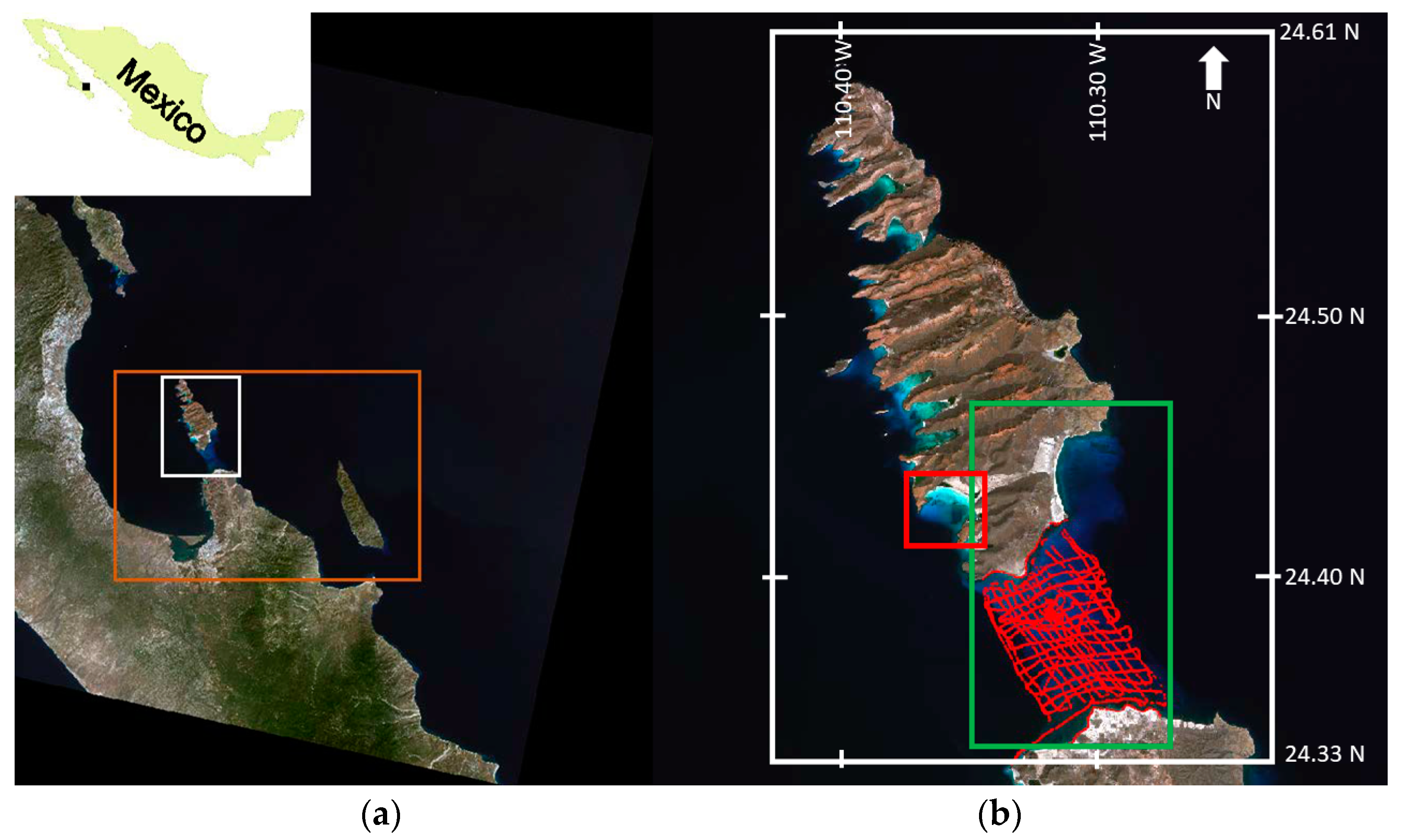
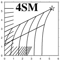
Satellite-derived bathymetry methods over coastal areas were developed to deliver basic and useful bathymetry information. However, the process is not straightforward, the main limitation being the need for field data. The Self-calibrated Spectral Supervised Shallow-water Modeler (4SM) method was tested to obtain coastal bathymetry without the use of any field data. Using Landsat-8 multispectral images from 2013 to 2016, a bathymetric time series was produced. Groundtruthed depths and an alternative method, Stumpf’s Band Ratio Algorithm, were used to verify the results. Retrieved (4SM) vs groundtruthed depths scored an average r2 (0.90), and a low error (RMSE = 1.47 m). 4SM also showed, over the whole time series, the same average accuracy of the control method (40%). Advantages, limitations and operability under complex atmosphere and water column conditions, and high and low-albedo bottom processing capabilities of 4SM are discussed. In conclusion, the findings suggest that 4SM is as accurate as the commonly used Stumpf’s method, the only difference being the independence of 4SM from previous field data, and the potential to deliver bottom spectral characteristics for further modeling. 4SM thus represents a significant advance in coastal remote sensing potential to obtain bathymetry and optical properties of the marine bottom.
F Favoretto, Y Morel, A Waddington, J Lopez-Calderon, M Cadena-Roa, A Blanco-Jarvio
In Sensor,
2017